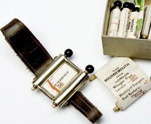
A SatNav From the 1920s!
 Back in the 1920s, they didn’t have portable computers. Or satellites. Or many roads. Or many cars.
For those that had a car and needed to know where to go, you had the only one option: paper maps. This little wrist-watch sized device provided the maps in a smaller, more portable form than even today’s GPS devices.
You could only “load” one route at a time from a series of “scrolls” inserted into the watch. You most certainly didn’t get anything like real-time traffic or up-to-date maps from the cellular phone network. Or the ability to play music and watch videos.
You only think trying to mess with your GPS while driving is dangerous today. I can’t imagine trying to insert these scrolls into the phone while driving as being easy.

